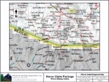
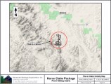
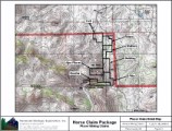
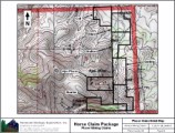
Colt, Mare, Stallion, Gelding
Filly, Quarter, & Ajax Placer
Placer Mining Claims
±140 Acres
Price: $10,000 for each claim
OR
Package Price: $60,000
Colt
Estimated GPS Coordinates:
Please adjust GPS to the following Datum & Coordinate display:
Datum: NAD83/WGS84
Coordinates: Decimal Degrees
|
Latitude
|
Longitude
|
Elevation
|
| Northeast Corner Boundary & Discovery Monument: |
|
31.55048° N
|
111.33823° W
|
3761 ft.
|
|
Northwest Corner Boundary:
|
|
31.55048° N
|
111.34151° W
|
3746 ft.
|
| Outer Western Corner: |
|
31.54863° N
|
111.34151° W
|
3812 ft.
|
| Inner Western Corner: |
|
31.54863° N
|
111.34026° W
|
3779 ft.
|
| Southwest Corner Boundary: |
|
31.54775° N
|
111.34026° W
|
3788 ft.
|
| Southeast Corner Boundary: |
|
31.54775° N
|
111.33823° W
|
3762 ft.
|
| Chilton Ranch Road Enters/Exits Northern Boundary: |
|
31.55048° N
|
111.34106° W
|
3745 ft.
|
Click here Google Earth Fly To and see an aerial photo of the Colt and the claim boundaries.

Mare
Estimated GPS Coordinates:
Please adjust GPS to the following Datum & Coordinate display:
Datum: NAD83/WGS84
Coordinates: Decimal Degrees
|
Latitude
|
Longitude
|
Elevation
|
| Northeast Corner Boundary: |
|
31.54955° N
|
111.33622° W
|
3792 ft.
|
|
Northwest Corner Boundary:
|
|
31.54955° N
|
111.33822° W
|
3760 ft.
|
| Southwest Corner Boundary & Discovery Monument: |
|
31.54692° N
|
111.33822° W
|
3770 ft.
|
| Southeast Corner Boundary: |
|
31.54692° N
|
111.33519° W
|
3781 ft.
|
| Outer Eastern Corner: |
|
31.54875° N
|
111.33519° W
|
3773 ft.
|
| Inner Eastern Corner: |
|
31.54875° N
|
111.33622° W
|
3777 ft.
|
| Tres Bellotas Road Enters/Exits Northern Boundary: |
|
31.54955° N
|
111.33662° W
|
3795 ft.
|
| Gulch @ Western Boundary: |
|
31.54882° N
|
111.33822° W
|
3753 ft.
|
| Gulch Forks @: |
|
31.54853° N
|
111.33742° W
|
3753 ft.
|
Click here Google Earth Fly To and see an aerial photo of the Mare and the claim boundaries.

Stallion
Estimated GPS Coordinates:
Please adjust GPS to the following Datum & Coordinate display:
Datum: NAD83/WGS84
Coordinates: Decimal Degrees
|
Latitude
|
Longitude
|
Elevation
|
| Northeast Corner Boundary: |
|
31.54692° N
|
111.33519° W
|
3781 ft.
|
|
Northwest Corner Boundary & Discovery Monument:
|
|
31.54692° N
|
111.33822° W
|
3770 ft.
|
| Southwest Corner Boundary: |
|
31.54318° N
|
111.33822° W
|
3781 ft.
|
| Southeast Corner Boundary: |
|
31.54318° N
|
111.33719° W
|
3803 ft.
|
| Access Road @ Inner Eastern Corner Boundary: |
|
31.54513° N
|
111.33719° W
|
3780 ft.
|
| Outer Eastern Corner: |
|
31.54513° N
|
111.33519° W
|
3797 ft.
|
| Access Road @ Northern Boundary: |
|
31.54692° N
|
111.33599° W
|
3777 ft.
|
| Well @: |
|
31.54579° N
|
111.33702° W
|
3782 ft.
|
Click here Google Earth Fly To and see an aerial photo of the Stallion and the claim boundaries.

Gelding
Estimated GPS Coordinates:
Please adjust GPS to the following Datum & Coordinate display:
Datum: NAD83/WGS84
Coordinates: Decimal Degrees
|
Latitude
|
Longitude
|
Elevation
|
| Northeast Corner Boundary: |
|
31.54318° N
|
111.33602° W
|
3838 ft.
|
|
Northwest Corner Boundary & Discovery Monument:
|
|
31.54318° N
|
111.33822° W
|
3781 ft.
|
| Southwest Corner Boundary: |
|
31.53966° N
|
111.33822° W
|
3829 ft.
|
| Southeast Corner Boundary: |
|
31.53966° N
|
111.33602° W
|
3916 ft.
|
| Access Road @ Northern Boundary: |
|
31.54318° N
|
111.33737° W
|
3798 ft.
|
Click here Google Earth Fly To and see an aerial photo of the Gelding and the claim boundaries.

Filly
Estimated GPS Coordinates:
Please adjust GPS to the following Datum & Coordinate display:
Datum: NAD83/WGS84
Coordinates: Decimal Degrees
|
Latitude
|
Longitude
|
Elevation
|
| Northeast Corner Boundary: |
|
31.53966° N
|
111.33602° W
|
3916 ft.
|
|
Northwest Corner Boundary & Discovery Monument:
|
|
31.53966° N
|
111.33822° W
|
3829 ft.
|
| Outer Western Corner: |
|
31.53680° N
|
111.33822° W
|
3863 ft.
|
| Inner Western Corner: |
|
31.53680° N
|
111.33602° W
|
3839 ft.
|
| Access Road @ Southwest Corner Boundary: |
|
31.53584° N
|
111.33602° W
|
3848 ft.
|
| Southeast Corner Boundary: |
|
31.53584° N
|
111.33471° W
|
3876 ft.
|
| Outer Eastern Corner Boundary: |
|
31.53778° N
|
111.33471° W
|
3937 ft.
|
| Inner Eastern Corner: |
|
31.53778° N
|
111.33602° W
|
3854 ft.
|
Click here Google Earth Fly To and see an aerial photo of the Filly and the claim boundaries.

Quarter
Estimated GPS Coordinates:
Please adjust GPS to the following Datum & Coordinate display:
Datum: NAD83/WGS84
Coordinates: Decimal Degrees
|
Latitude
|
Longitude
|
Elevation
|
| Northeast Corner Boundary: |
|
31.53780° N
|
111.34000° W
|
4050 ft.
|
|
Northwest Corner Boundary:
|
|
31.53780° N
|
111.34243° W
|
4060 ft.
|
| Southwestern Corner Boundary & Discovery Monument: |
|
31.53584° N
|
111.34243° W
|
4001 ft.
|
| Southern Corner Boundary: |
|
31.53584° N
|
111.335861° W
|
4001 ft.
|
| Access Road @ Southeast Corner Boundary: |
|
31.53584° N
|
111.33602° W
|
3848 ft.
|
| Outer Eastern Corner Boundary: |
|
31.53680° N
|
111.33602° W
|
3839 ft.
|
| Inner Eastern Corner: |
|
31.53680° N
|
111.34000° W
|
3887 ft.
|
Click here Google Earth Fly To and see an aerial photo of the Quarter and the claim boundaries.

Ajax Placer
Estimated GPS Coordinates:
Please adjust GPS to the following Datum & Coordinate display:
Datum: NAD83/WGS84
Coordinates: Decimal Degrees
|
Latitude
|
Longitude
|
Elevation
|
| Northeast Corner Boundary: |
|
31.54066° N
|
111.33823° W
|
3822 ft.
|
|
Northwest Corner Boundary:
|
|
31.54066° N
|
111.34225° W
|
4037 ft.
|
| Southwest Corner Boundary: |
|
31.53868° N
|
111.34225° W
|
4130 ft.
|
| Southeast Corner Boundary: |
|
31.53868° N
|
111.33823° W
|
3825 ft.
|
Click here Google Earth Fly To and see an aerial photo of the Ajax Placer and the claim boundaries.

Standard Information
Advanced Geologic is a professional geologic consulting firm located in Chester, California. We not only sell quality mining claims, but we also help people work their claims. Our experience in resource evaluations, compliance and permitting and claim portfolio management allows our clients and buyers to go for the GOLD.
Interested? Send us an email or call.